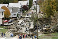
First the Gulf Port Region and Now New England, Heavy Flooding causes havoc
Heavy rains and East Coast flooding have left 14 missing as residents in New England towns access the damage and search for unaccounted individuals.
Residents began assessing the damage left by deadly flooding that tore up highways, swept away houses and tossed boulders and vehicles around like toys. More than a dozen people remained unaccounted-for in hard-hit southwest New Hampshire.
Due to the non-stop heavy rains that caused damage and destruction in New Hampshire, NH Governor Lynch has asked for a federal disaster declaration, which would make the state eligible for federal reconstruction help.
The most severe flooding in the state was in and around Keene, where some major roads were under as much as 4 to 6 feet of water, officials said. The city had no electricity and reverberated with the sounds of generators and pumps Monday when Gov. John Lynch visited.
From Friday evening through Sunday, rainstorms dumped as much as 9 to 10 inches on New England and the mid-Atlantic states. In New Hampshire, the storm dropped 10.8 inches in Hinsdale and 10.5 inches in Keene.
Many areas Looked Like New Orleans, but it was not, At Least 10 Feared Dead In Northeast Floods.
If you think it looks familiar, look again. No its not New Orleans or the Gulf Coast regions. It is New England. To be specific, its Keene, NH. Known this time of year for its picturesque fall foliage and leaf peepers; this weekend tragedy and mother nature struck.
More than a dozen people missing in floodwaters
Towns across New England access the damage of the flooding as even more rain is predicted for the future.
Shortly before 8 a.m., the Southern New England NWS office in Taunton, Mass., which issues forecasts for Connecticut, Rhode Island, Massachusetts and Cheshire and Hillsborough counties in New Hampshire, issued the following advisory:
A FLOOD POTENTIAL STATEMENT IS POSTED FOR REMAINDER OF SOUTHERN NEW ENGLAND WITH SPECIAL ATTENTION ON THURSDAY. ONE TO 3 INCHES OF RAIN WILL FALL IN ALL OF SOUTHERN NEW ENGLAND WITH SPOTTY 5 INCH AMOUNTS POSSIBLE. THINKING OF WHERE IT RAINED MORE THAN 4 INCHES OVER THE PAST FEW DAYS…A 24 HOUR RAINFALL OF 3 INCHES WOULD LEAD TO URBAN POOR DRAINAGE FLOODING AS WELL AS A POSSIBLE RENEWAL OF LAST WEEKENDS SMALL STREAM AND RIVER FLOODING AND…IN SOME CASES…POCKETS OF NEWLY DEVELOPED RIVER FLOODING. THERE EXISTS UNCERTAINTY AS TO ULTIMATELY WHERE THE HEAVIEST RAIN WILL OCCUR. AREAS OF CONCERN FOR POSSIBLE 5 INCH AMOUNTS ARE APPARENT FOR THE EAST SLOPES OF BOTH THE LITCHFIELD HILLS AND BERKSHIRES AS WELL AS THE NORTHEAST PART OF MASSACHUSETTS…THE MERRIMACK VALLEY…THE WORCESTER HILLS AND THE EAST SLOPES OF THE MONADNOCKS.
If you liked this post, you may also like these:
Comments
Leave a Reply

 RSS
RSS


