Hurricane Irene About to Make Landfall Heading Toward North Carolina
Posted in: Hurricane,Natural Disaster
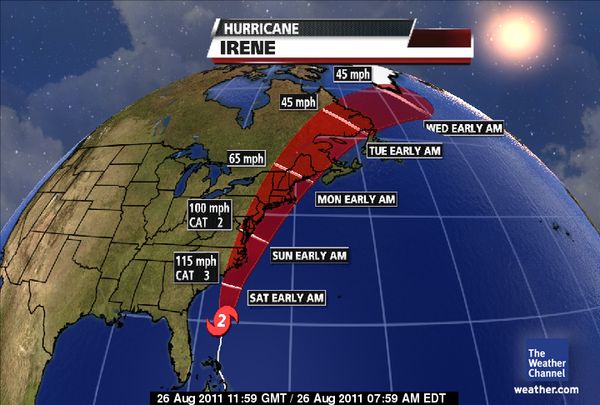
Everyone please take precautions and be safe, Hurricane Irene is about to make landfall and is predicted to affect the areas of the Mid-Atlantic to New England. Irene is reported at being 420 miles south-southwest of Cape Hatteras, NC and has winds near 110 miles per hour, and was moving to the north at 14 miles per hour. When it finally hits land on Saturday, Irene is supposed to be a category 2 or 3 hurricane.
Pic: The Weather Channel
- Hurricane Irene poses an extraordinary threat and is one that no one has yet experienced from North Carolina to the mid_Atlantic to the Northeast to New England.
- Hurricane Irene is a high end category 2 hurricane on the Saffir-Simpson Hurricane Wind Scale; however, Irene is expected to re-strengthen into a category 3 storm.
From ABC News, Hurricane Irene is predicted to cause billions in damages.
“This is going to have an impact on the United States economy,” Mayfield added.
The head of the Federal Emergency Management Agency (FEMA) noted the high value of property in major U.S. East Coast cities like New York, Philadelphia and Boston.
“We’ve got a lot more people that are potentially in the path of this storm,” FEMA Director Craig Fugate told the Associated Press. “This is one of the largest populations that will be impacted by one storm at one time. A little bit of damage over big areas with large populations can add up fast.”
Follow the path and get emergency advisories at NOLA … HERE, HERE and HERE (radar).
PLEASE BE SAFE!
Brian in a Blue State
Return to: Hurricane Irene About to Make Landfall Heading Toward North Carolina

Social Web